Surveys
-
font size
decrease font size
 increase font size
There are two major categories of Surveying: geodetic and plane surveying. Geodetic surveys consider the surface of the earth as being accurately curved, whereas plane surveys assume the earth is flat, which is functionally accurate for the short distances involved in almost all construction work. There are many categories of plane surveys, which are referenced to an accepted level plane such as mean sea level or the North American Datum.

Topic Summary
In the context of construction projects, surveys are required to identify the boundaries of the project site and establish the positions of improvements within it, when compared to construction plans. Therefore, the surveys that routinely concern construction professionals will be topographic surveys (to indicate site features and elevations), control surveys (to install reference monuments for future surveys’ use), land surveys (to define property lines), and construction surveys (to establish lines and grades for site improvements). As-built surveys may follow construction surveys to indicate actual locations of placed structures that deviate from original plans. Route surveys may be of interest to highway, utility or railroad construction professionals or others working on straight-line projects referenced to successive control points. Bathymetric or marine surveys that define water depths will be of interest to waterway project stakeholders.
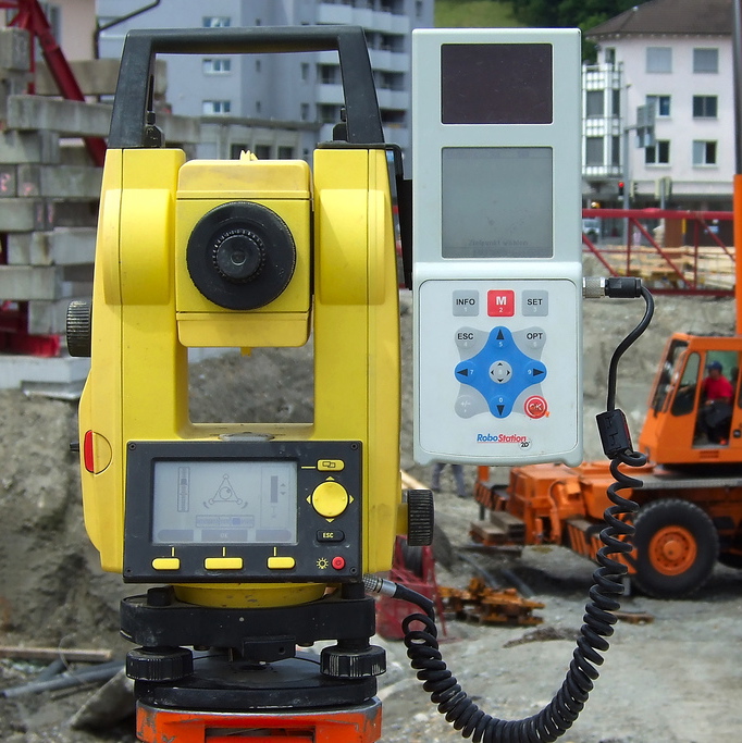 There are five kinds of basic measurements involved in control, land, and construction surveys that most construction project work is referenced to. These are horizontal angles, horizontal distances, vertical angles, vertical distances and slope distances. The traditional surveying equipment used to make these measurements are the theodolite for horizontal and vertical angles, chains or tapes for distance, and calibrated rods for elevation measurements. The theodolite is tripod mounted to a level attitude, with calibrated horizontal and vertical plates that indicate any angular movements of a telescopic aiming lens. The various distance and angular measurements are recorded in the field, and then computations based on trigonometry and geometry are completed and drawn. In state of the art surveying, electronic measurement equipment and techniques have simplified these elements into one piece of equipment termed a “total station”. A “total station” includes an electronic theodolite that can record vertical and horizontal angle deviations of the optic, and electronic (microwave or infrared) equipment that can accurately measure the distance to a target object. Calculations are done by integrated computer systems or are downloaded for completion on a desktop computer.
Land surveys to define property boundaries are usually “closed traverse” surveys. A starting point, such as one property corner, is identified in reference to a monument established in a prior control survey. From the starting point, all property boundaries and corners are further established by distance, azimuth (horizontal angle), and elevation change, forming a closed loop back to the starting point.
Construction surveys will determine the reference lines and grades required to fix the exact locations for site improvements, such as the corners of new buildings and routes for utility runs. Construction surveys are referenced to monuments established in control surveys or to the property boundaries defined in land surveys. Straight lines and elevation benchmarks that can be consistently referenced throughout a construction project are established first. These reference lines and grades are typically offset from the limits of new work. This allows removable stakes to be fixed in the exact locations required until the construction begins on each site improvement.


Buildipedia Staff
The Buildipedia research and writing staff consists of dozens of experienced professionals from many sectors of the industry, including architects, designers, contractors, and engineers.
Website: buildipedia.com/