Buildipedia Staff

Buildipedia Staff

The Buildipedia research and writing staff consists of dozens of experienced professionals from many sectors of the industry, including architects, designers, contractors, and engineers.

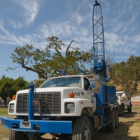
Seismic Investigations

Wed, Oct 14, 2009

This topic includes information related to seismic investigations performed prior to construction. Seismic investigations survey soil stability to understand soil composition, solidity and quality in addition to determining the depth of soil layers, bedrock and water table. The results define the suitability of land for development, volume of excavation, and structural requirements.

Asbestos Assessment

Wed, Oct 14, 2009

This topic includes information related to asbestos assessment performed prior to construction. Asbestos is natural mineral used in a variety of building materials from the late 19th century and in to the 20th century. Asbestos assessment is a process that evaluates existing conditions of a structure to quantify the existence of this hazardous material.

Environmental Assessment

Wed, Oct 14, 2009

This topic includes information related to environmental assessment performed prior to construction. Land development decisions impact the natural environment. Environmental assessment is a process that evaluates existing conditions of air, water and land to understand these potential impacts. Understanding what impact a new development may have on existing conditions, allows for solutions that improve existing conditions to be included as part of the land development plan.

Traffic Assessment

Wed, Oct 14, 2009

This topic includes information related to traffic assessment performed prior to construction. Land development decisions impact transportation. Traffic assessment is a process that evaluates existing conditions to understand these potential impacts. Understanding what impact a new development may have on existing conditions, allows for solutions that improve existing conditions to be included as part of the land development plan.

Geosynthetics for Existing Conditions

Wed, Oct 14, 2009

This topic includes information related to the common work results of geosynthetics used in a variety of civil and site development existing condition applications. Geosynthetics generally include a wide range of polymeric products; geotextiles, geogrids, geonets, geomembranes, geosynthetic clay liners, geofoam, geocells and geocomposites. They function as designed for specific applications such as, separation, reinforcement, filtration, drainage and containment.

Mold Remediation

Tue, Aug 10, 2010

A popular but false notion is that mold (a fungus) only grows within dark, wet spaces inside a building. In actuality, mold spores can be carried from the outdoors into a building by people, ventilation systems, and even pets and open windows. Once inside, spores can mature into visible colonies if proper conditions are met -- moderate temperature, available moisture, and a food source.

Groundwater Treatment

Wed, Oct 14, 2009

Fresh water infiltrates into the ground from precipitation and melting ice.  Infiltrated water that moves through soil and rock prior to meeting the groundwater table is considered unsaturated flow, evident in varying degrees of soil moisture.  The groundwater table is defined by the first depth at which all soil and rock void spaces are completely filled with water, at atmospheric pressure.  Water below the groundwater table behaves as saturated flow, where the soil and rock voids are completely filled with water, and pressure increases with greater depth.  Groundwater will move from areas of greater to lesser hydraulic pressure along flow nets which can be predicted by understanding the types of soils present, and determining the elevation of the groundwater table at specific site locations.  Flow nets will often transition groundwater back to the earth’s surface by connecting into lakes, rivers and springs.  Groundwater is the source of well water for millions of people, and represents about one fourth of the world’s total freshwater supply.

Landfill Construction and Storage

Wed, Oct 14, 2009

Landfills store waste materials at an engineered and self-contained site to decompose in a controlled setting.  The term “landfill” implies a simple earth excavation filled with garbage.  While crude waste disposal practices occurred over many previous decades, modern landfills are carefully prepared structures with many common design features.  Many landfills safely serve a secondary function such a recreational park or golf course when their maximum capacities are reached.  Most landfills are solid waste landfills that receive municipal refuse originating from homes, businesses and institutions.  There are some specialized landfills that receive specific industrial wastes including liquids.  Even within solid waste landfills, liquid containment is essential because of leachate production.  Leachate is an organic waste liquid, a by-product of solid waste moisture and decomposition, mixed with any precipitation or groundwater infiltrating through the landfill.  Modern landfill designs will include a bottom layer, a leachate recovery system, a surface cap, and gas release capability, as methane is generated within landfills as organic wastes decompose.

Geotechnical Investigations

Wed, Oct 14, 2009

The purpose of a Geotechnical Investigation is to determine the engineering qualities of the soils or rocks at a site, and how their location and depth affects an envisioned construction project. The presence of any buried organic materials with poor engineering qualities, obstructions to earthwork, and the depth of the water table are also important to identify during a geotechnical investigation. Prior to initiating expensive field work, an initial sense of soil conditions for specific localities may be obtained through government soil surveys that have been recorded for most of the United States. Geotechnical investigations prepared for adjacent construction projects are another potential source of available site information.

Surveys

Wed, Oct 14, 2009

There are two major categories of Surveying: geodetic and plane surveying. Geodetic surveys consider the surface of the earth as being accurately curved, whereas plane surveys assume the earth is flat, which is functionally accurate for the short distances involved in almost all construction work. There are many categories of plane surveys, which are referenced to an accepted level plane such as mean sea level or the North American Datum.